The Future of GIS: Key Trends and Innovations to Watch
Introduction
The 21st century has been defined by data. Every action we take—whether browsing online, traveling, shopping, or engaging on social media—leaves behind a trail of information. But among all forms of data, spatial data has emerged as one of the most powerful drivers of innovation. This is where Geographic Information Systems (GIS) step in.
From tracking the spread of diseases to planning smart cities, GIS is revolutionizing how organizations analyze and interpret information tied to geography. Beyond just maps, GIS now integrates artificial intelligence, big data, drones, augmented reality, and real-time data streams.
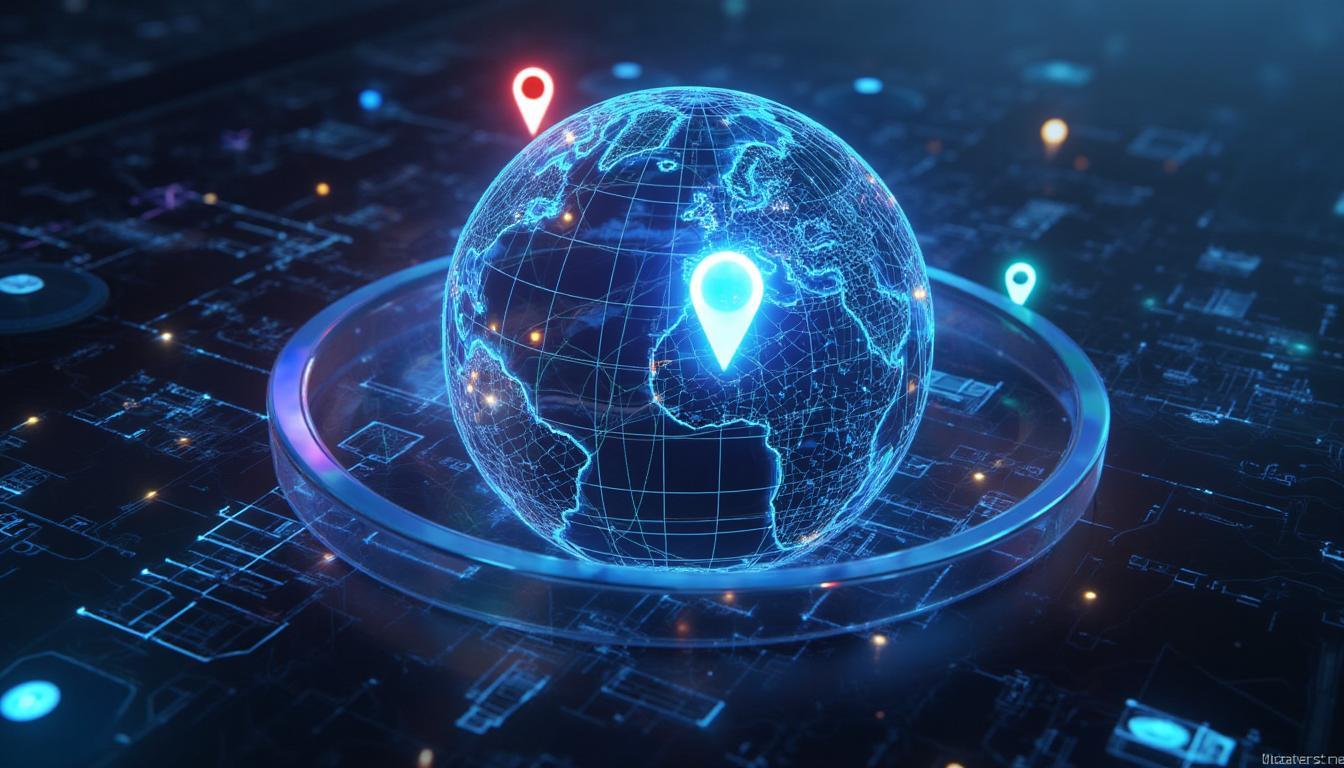
The global market for GIS is expanding rapidly, with governments, enterprises, and researchers investing in next-gen spatial solutions. Central to this growth is the evolution of GEO Services, which are enabling real-time access to location intelligence for businesses and individuals.
In this blog, powered by thought leadership from Adomantra, we explore the future of GIS, the key trends shaping its growth, and the innovations that will define its role in tomorrow’s world.
1. The Evolution of GIS Technology
The roots of GIS date back to the 1960s, when Roger Tomlinson, often called the “father of GIS,” developed the first computerized system for handling geographic data in Canada. Back then, GIS was limited to academic research and government projects. Over the decades, however, it evolved into a mainstream tool powering global industries.
-
1970s–1980s: Early GIS systems were expensive, hardware-heavy, and primarily used by defense and environmental agencies.
-
1990s: The rise of personal computing and the internet transformed GIS into accessible desktop applications. Companies like ESRI led the wave with ArcGIS.
-
2000s: GIS merged with mobile technology, enabling location-based services (like GPS navigation).
-
2010s–2020s: Cloud-based GIS and real-time platforms emerged, democratizing access to spatial analytics for businesses of all sizes.
Today, GIS is no longer just a technical mapping tool. It is the backbone of GEO Services, integrating seamlessly with web platforms, apps, and smart technologies that inform how we live, work, and plan for the future.
2. Artificial Intelligence and Machine Learning in GIS
Artificial Intelligence (AI) and Machine Learning (ML) are driving massive transformations across industries, and GIS is no exception.
-
Predictive Analytics: AI can process satellite imagery to forecast environmental changes, such as deforestation, glacier melting, or agricultural yield.
-
Automated Object Recognition: Machine learning algorithms can detect roads, buildings, vehicles, and even people in geospatial imagery with remarkable accuracy.
-
Route Optimization: AI-powered GIS helps logistics and delivery companies find the fastest, most fuel-efficient routes.
-
Disaster Management: By analyzing historical weather patterns and live satellite data, AI models can predict and track natural disasters like hurricanes, wildfires, or floods.
The convergence of AI and GIS also gives rise to “intelligent maps,” where decisions are not just visualized but also recommended in real-time. For example, Adomantra has been working on creating AI-driven GEO solutions that empower businesses to anticipate customer behavior based on geospatial intelligence.
3. The Role of Big Data in GIS
With billions of connected devices generating terabytes of data every day, big data has become a core component of GIS.
-
IoT Integration: Sensors embedded in vehicles, smart homes, factories, and mobile devices generate constant streams of geospatial data.
-
Real-Time Analytics: GIS can process massive volumes of this data, enabling cities to monitor traffic congestion, environmental conditions, and energy usage in real-time.
-
Health and Epidemiology: During the COVID-19 pandemic, GIS-based dashboards tracked infection hotspots globally. This was one of the most impactful examples of how big data and GIS can save lives.
-
Retail and Consumer Insights: Businesses use geospatial big data to analyze customer movement, shopping patterns, and regional demand for products.
By combining big data with GIS, organizations can unlock patterns that would otherwise remain hidden. This is one of the core capabilities that companies like Adomantra leverage to provide actionable insights for clients in diverse industries.
4. Cloud-Based GIS and Web Mapping
In the past, GIS systems required heavy infrastructure and costly licensing. The cloud has changed everything.
-
Scalability: Cloud GIS allows organizations to scale up or down as per demand without worrying about hardware.
-
Accessibility: Teams spread across the world can collaborate on the same mapping projects in real-time.
-
Cost Efficiency: “GIS as a Service” reduces upfront investments for small and mid-sized enterprises.
-
Major Platforms: ArcGIS Online, Google Earth Engine, and open-source platforms like QGIS Cloud have made GIS more democratic.
Cloud integration has also expanded the adoption of GEO Services, particularly for businesses that need fast, location-based intelligence without building expensive infrastructures.
5. GIS in Smart Cities and Urban Planning
The rise of smart cities is inseparable from the advancements in GIS. With more than 70% of the world’s population projected to live in urban areas by 2050, city planners need intelligent solutions for sustainable growth.
-
Digital Twins: Virtual replicas of entire cities allow governments to simulate traffic flow, infrastructure development, and environmental impacts.
-
Traffic and Mobility: Real-time traffic monitoring helps reduce congestion and optimize public transport.
-
Public Safety: GIS enables emergency services to deploy resources quickly by analyzing live location data.
-
Urban Sustainability: Mapping renewable energy infrastructure and carbon emission zones.
Adomantra has been actively exploring GIS-powered solutions for urban development, offering insights that help cities transition to smarter, greener, and more livable spaces.
6. The Rise of Real-Time GIS
Traditional GIS relied on static datasets that were updated periodically. Real-time GIS changes the game.
-
Disaster Response: When earthquakes, floods, or wildfires strike, real-time GIS dashboards provide immediate data for decision-making.
-
Weather Forecasting: Satellite and radar streams feed GIS systems to provide accurate short-term forecasts.
-
Supply Chain Monitoring: Businesses can track shipments, manage warehouse inventory, and monitor global logistics networks in real-time.
The future of real-time GIS will be deeply integrated with 5G networks and IoT, making it possible to stream and analyze billions of data points instantly.
7. Drone and Satellite Innovations in GIS
Drones and satellites are giving GIS an unprecedented level of precision and reach.
-
Drones in Agriculture: Farmers use drone-based GIS to monitor soil health, crop conditions, and irrigation systems.
-
Satellite Constellations: Companies like SpaceX and Planet Labs are launching small-satellite constellations that provide daily, high-resolution imagery of Earth.
-
Disaster Mapping: After natural disasters, drones can capture damage assessments in areas too dangerous for humans to enter.
-
Mining and Energy: GIS integrated with drones improves resource exploration and monitoring of environmental compliance.
These innovations are creating new opportunities for GEO Services, especially for industries that depend on high-quality spatial imagery.
8. GIS and Augmented Reality (AR) / Virtual Reality (VR)
The blending of GIS with immersive technologies like AR and VR is creating entirely new experiences.
-
AR Navigation: Apps can overlay directions onto real-world environments for seamless travel guidance.
-
VR Training: Emergency responders can train in simulated disaster environments built with GIS data.
-
Tourism: AR-based experiences allow travelers to explore historical sites with location-based storytelling.
-
Construction and Real Estate: VR combined with GIS helps visualize how buildings will integrate into existing cityscapes.
In the coming years, Adomantra sees AR-powered GEO Services becoming central to industries such as retail, tourism, and urban development.
9. GIS for Environmental and Climate Solutions
One of the most powerful applications of GIS is in addressing climate change and sustainability.
-
Deforestation Mapping: Satellite imagery tracks illegal logging and forest degradation.
-
Biodiversity Protection: GIS helps identify critical habitats that need conservation.
-
Carbon Tracking: Companies can measure emissions spatially to plan reductions.
-
Disaster Preparedness: Climate risk maps inform where infrastructure investments should be made.
As sustainability becomes a global priority, GIS will play a key role in shaping a more resilient planet. Adomantra strongly advocates for integrating geospatial intelligence into sustainability initiatives.
10. Cybersecurity and Ethics in GIS
The rapid adoption of GIS brings challenges around security and ethics.
-
Privacy Concerns: Location tracking can raise serious questions about individual freedoms.
-
Data Security: Critical infrastructures like power grids and transport systems rely on GIS, making them vulnerable to cyberattacks.
-
Ethical Dilemmas: Governments and organizations must balance surveillance with human rights.
-
Equity Issues: Ensuring that GIS benefits are accessible across all communities is essential.
Future GIS frameworks will need strong governance models that address these ethical challenges without stifling innovation.
11. GIS and the Future of Work
The demand for GIS professionals is skyrocketing as industries realize the value of spatial intelligence.
-
Growing Career Pathways: GIS analysts, geospatial data scientists, drone mapping specialists, and AR/VR GIS developers are in demand.
-
Enterprise Adoption: GIS is no longer limited to geography departments; it is becoming central to supply chain, marketing, and operations.
-
Workforce Training: Educational institutions are expanding geospatial programs, and businesses like Adomantra are investing in training modules for employees.
GIS will become a critical skill for the workforce of tomorrow, much like data science and AI are today.
12. Predictions: The Next Decade of GIS
Looking ahead, several key innovations are poised to define the future of GIS:
-
Integration with 5G and IoT: Billions of connected devices feeding live geospatial data streams.
-
AI-Powered Decision Engines: Intelligent GIS platforms recommending real-time actions.
-
Immersive GEO Services: Augmented and virtual reality platforms offering interactive mapping.
-
Democratization of GIS: Affordable, user-friendly platforms making GIS accessible to startups and small businesses.
-
Global Collaboration: Cloud-based GIS allowing cross-border projects in climate research, urban planning, and humanitarian aid.
Conclusion
The future of GIS is about more than maps—it’s about creating a smarter, more connected world. With the rise of AI, real-time data, cloud platforms, and immersive technologies, GIS will continue to redefine how industries and societies function.
The evolution of GEO Services will make location intelligence accessible to every business and individual, opening new opportunities for growth, innovation, and sustainability.
At Adomantra, we believe that embracing these innovations is essential for organizations that want to stay ahead in a competitive world. GIS is not just a tool of the future—it is the foundation upon which the future itself will be built.
FAQ: The Future of GIS – Trends and Innovations
1. What is GIS and why is it important?
GIS (Geographic Information Systems) is a framework for collecting, analyzing, and visualizing spatial data. It goes beyond maps, offering insights into patterns, relationships, and trends that are tied to geography. GIS is critical for industries like urban planning, logistics, disaster management, and environmental monitoring because it helps decision-makers act with precision.
2. What are GEO Services?
GEO Services refer to location-based digital services powered by GIS and mapping technologies. These services include real-time navigation, geocoding, route optimization, and spatial data analysis. Businesses use GEO Services for logistics, retail insights, and personalized customer engagement.
3. How will Artificial Intelligence change the future of GIS?
AI will allow GIS platforms to automatically process satellite imagery, predict environmental changes, and provide intelligent recommendations. For example, AI-driven GIS can detect urban growth patterns, optimize logistics routes, and forecast climate risks without human intervention.
4. What role does Big Data play in GIS?
Big data enhances GIS by providing massive volumes of information from IoT sensors, social media, satellites, and mobile devices. This integration allows GIS systems to generate real-time insights for transportation, health, urban planning, and supply chain management.
5. How do GEO Services benefit businesses?
GEO Services help businesses understand customer behavior, optimize supply chains, and improve marketing strategies. For example, retailers use geospatial data to identify high-demand areas, while logistics companies use it to plan efficient delivery routes.
6. What is the future of GIS in smart cities?
GIS will be central to smart city planning by enabling digital twins (virtual models of cities), real-time traffic management, resource allocation, and sustainable infrastructure design. Cities of the future will rely heavily on GIS to enhance livability and resilience.
7. How is real-time GIS transforming industries?
Real-time GIS allows instant analysis of live data streams. For example, emergency services can track and respond to natural disasters as they unfold, logistics companies can monitor shipments in transit, and meteorologists can provide accurate short-term forecasts.
8. What role do drones and satellites play in GIS?
Drones and satellites provide high-resolution imagery and remote sensing data for GIS. Drones are widely used in agriculture, mining, and construction, while satellites provide global coverage for climate monitoring, deforestation mapping, and disaster assessment.
9. What are the ethical concerns around GIS and GEO Services?
The main concerns are data privacy, surveillance risks, and cybersecurity. Since GIS involves location tracking, misuse of data could compromise personal freedoms. Companies like Adomantra emphasize responsible innovation, ensuring geospatial technologies are used ethically and securely.
10. How does GIS help in environmental and climate solutions?
GIS is essential for monitoring deforestation, mapping biodiversity, analyzing carbon emissions, and modeling climate risks. Governments and organizations rely on GIS to make informed decisions for sustainability and conservation projects.
11. What industries use GIS the most?
GIS is used across multiple industries, including:
-
Urban planning and real estate
-
Transportation and logistics
-
Agriculture and forestry
-
Disaster management and environmental science
-
Retail and marketing
-
Defense and security
12. Will GIS and GEO Services become more accessible to small businesses?
Yes. With the rise of cloud-based GIS platforms, even small businesses can now access powerful spatial intelligence without large investments. Affordable GEO Services allow startups and SMEs to benefit from location-based insights.
13. How is GIS used in disaster management?
GIS helps map hazard zones, monitor disaster progression, and plan emergency response. During events like hurricanes, wildfires, or earthquakes, real-time GIS provides critical situational awareness for deploying resources effectively.
14. What skills will be important for GIS professionals in the future?
Future GIS professionals will need expertise in:
-
Spatial data science
-
Artificial intelligence and machine learning
-
Drone mapping and remote sensing
-
Cloud-based GIS platforms
-
AR/VR for geospatial applications
Organizations like Adomantra are already training teams in these emerging skills.
15. What does the next decade of GIS look like?
The next decade will see:
-
Widespread adoption of AI-driven GEO Services
-
Integration of GIS with 5G and IoT
-
Growth of real-time geospatial dashboards
-
Immersive GIS through AR and VR
-
A global shift toward sustainable, GIS-enabled decision-making
Κατηγορίες
Διαβάζω περισσότερα
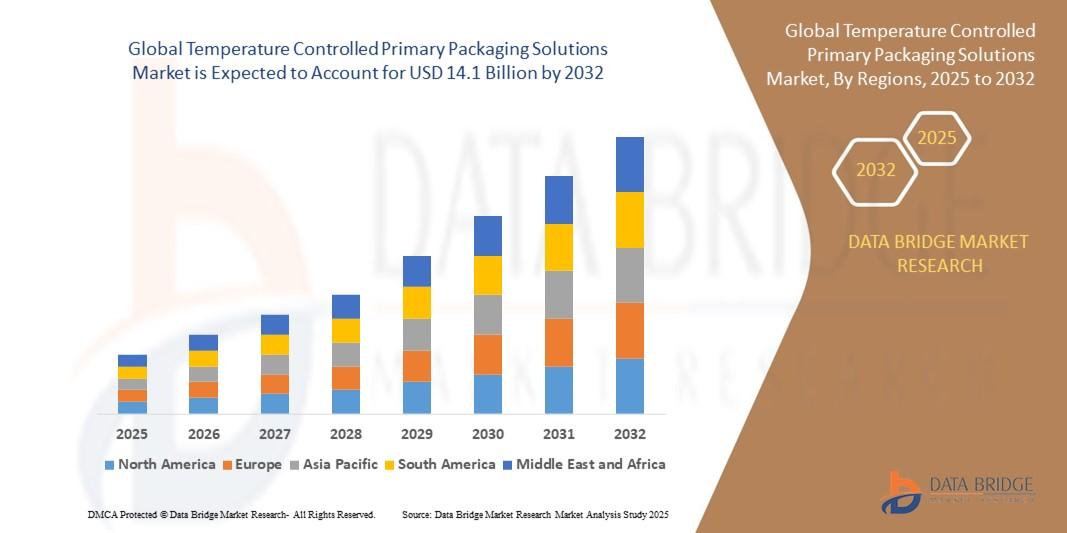
Regional Overview of Executive Summary Temperature Controlled Primary Packaging Solutions Market by Size and Share The Global Temperature Controlled Primary Packaging Solutions Market size was valued at USD 8.5 billion in 2024 and is expected to reach USD 14.1 billion by 2032, at a CAGR of 8.5% during the forecast period With the superior Temperature Controlled...
Custom burger paper is one of the most invaluable goods when it comes to the food branding and packaging industry in the contemporary world. In addition to serving its purpose, it also works as a creative zone where you can exhibit your business identity to the customers, hence augmenting customer experience. Customized wrap is the best way to make sure your food is still fresh, looks great,...
Introduction If you’re planning a trip to Thailand, you’ve probably heard about its beautiful beaches, rich culture, and electric nightlife. But there’s one experience that often surprises and delights visitors: the Colosseum Show Pattaya. This glamorous cabaret is more than just a performance — it’s an evening packed with music, dance, color, and the undeniable...

Escort Service in Connaught Place are well-educated girls or women who belong to a good family with the best income-earning capacity and also have experience in the modeling industry which may be closer to 2 years or not less than 3 years. Our divas are known as the most soft-hearted escorts because they also are just like normal human beings like you and us but they are highly fluent in the...

London is a city filled with history, culture, and modern elegance. Its iconic landmarks, charming streets, and grand architecture offer an unmatched sightseeing experience. However, the way you choose to explore the city can shape your entire visit. For those seeking comfort, class, and convenience, chauffeur-driven sightseeing is the ultimate way to discover London’s finest. Touring in...